Above-Ground Biomass,
measured with satellite precision.
Sylithe quantifies Above-Ground Biomass (AGB) using canopy height models derived from space-borne LiDAR and radar delivering carbon stock estimates that satisfy Verra VCS, Gold Standard, and IC-VCM requirements.
Biomass Density Model
AGB Stock Estimate
What is Above-Ground Biomass and why does it matter?
AGB is the total living organic matter above the soil surface, expressed in tonnes of dry matter per hectare (Mg ha⁻¹). It is the primary variable from which carbon stocks and therefore carbon credits are derived.
IPCC Definition
Per the IPCC 2006 Guidelines, AGB encompasses all living biomass above the soil including stem, stump, branches, bark, seeds, and foliage. It is the largest pool in forest ecosystems and the foundation of any carbon accounting exercise.
Verra VCS Standard
Under VM0047, AGB must be estimated using allometric equations validated for the geographic region and forest type. Verra requires stratified sampling designs and demands uncertainty be reported at the 90% confidence interval a threshold Sylithe meets by default.
Gold Standard Protocol
Gold Standard's Land Use & Forestry Activity requirements mandate that AGB estimation methods demonstrate equivalence to ground-truthed allometric models. Remote sensing approaches must be validated against field plots, a process Sylithe automates using its global calibration dataset.
Canopy height is the single most important predictor of AGB.
Across tropical, temperate, and boreal forests, canopy height explains 60–85% of the variance in Above-Ground Biomass more than any other remotely sensed variable.
Sylithe's Canopy Height Model (CHM) integrates NASA GEDI waveform LiDAR, Sentinel-1 SAR time series, and Sentinel-2 optical reflectance into a fused 10 m product with <6 m height RMSE. This precision directly translates into AGB uncertainty that satisfies the 90% CI threshold mandated by Verra's VM0047 and VM0006 methodologies.
Unlike field-plot-only approaches, which are spatially sparse and temporally lagged, Sylithe's wall-to-wall CHM captures heterogeneous canopy structures edges, gaps, regrowth patches that inventory methods systematically miss.
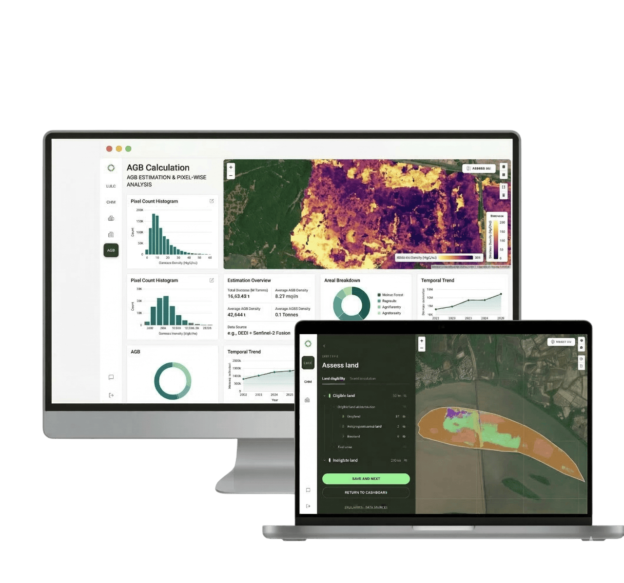
How Sylithe calculates AGB at scale.
CHM Generation
GEDI spaceborne LiDAR pulses are fused with Sentinel-1 SAR coherence and Sentinel-2 NDVI time series to produce a continuous, gap-filled 10 m canopy height map across the project area.
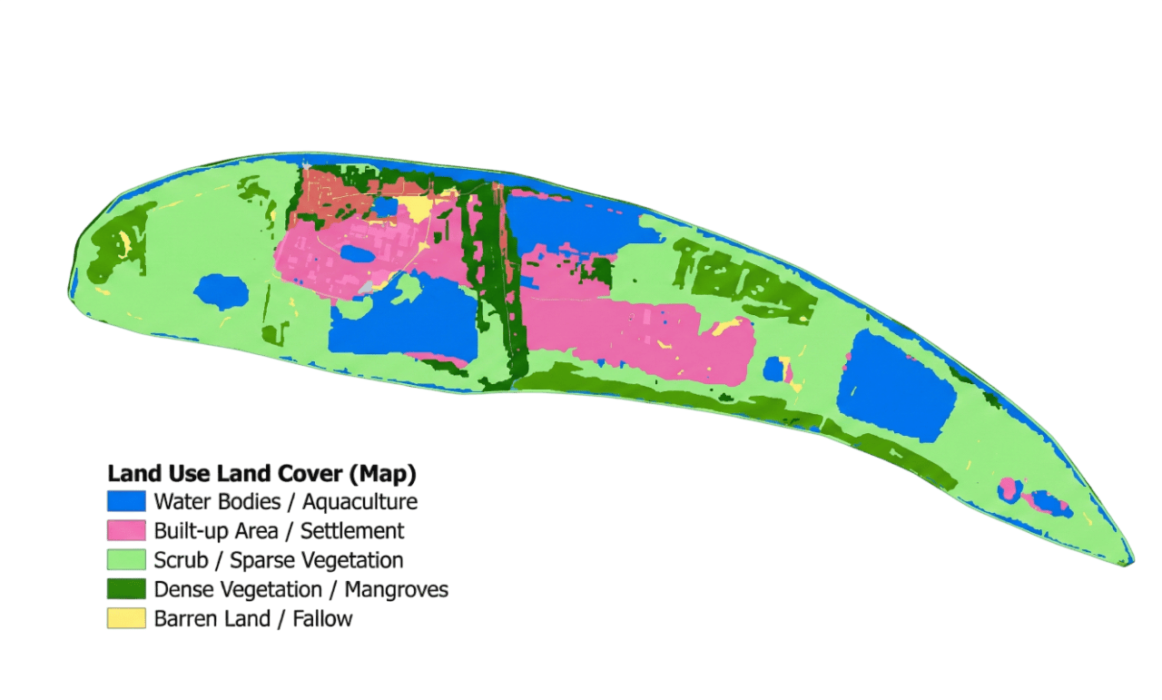
Forest Stratification
Canopy height pixels are stratified by forest type (tropical moist, tropical dry, temperate broadleaf, etc.) using a globally trained land cover classifier, ensuring the correct allometric model is applied in each stratum.
Allometric Conversion
Within each stratum, Sylithe applies validated height-to-AGB allometric equations (Chave et al. 2014; Jucker et al. 2017; local equations where available) to estimate per-pixel AGB density in Mg ha⁻¹.
Uncertainty Quantification
Monte Carlo propagation of CHM measurement error, allometric model uncertainty, and wood density variability produces a spatially explicit 90% confidence interval reported per stratum and project total.
Annual Stock Change
Year-over-year AGB delta (ΔAGB) is computed to distinguish net sequestration from disturbance-driven loss, feeding directly into the DCAB dynamic baseline for additional credit calculation.
Engineered for Verra, Gold Standard, and IC-VCM.
AGB estimation is not merely a scientific exercise it is a regulatory requirement. Every methodological choice Sylithe makes is traceable to published standards and peer-reviewed literature.
Uncertainty is not a weakness. It is a scientific obligation.
Under Verra's conservative crediting rules, unquantified uncertainty triggers automatic deductions. Sylithe eliminates this risk by making uncertainty explicit, propagated, and reported.
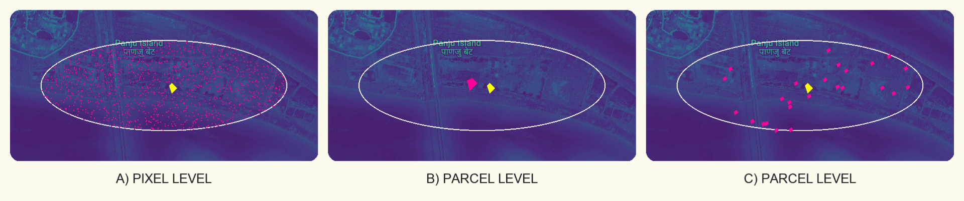
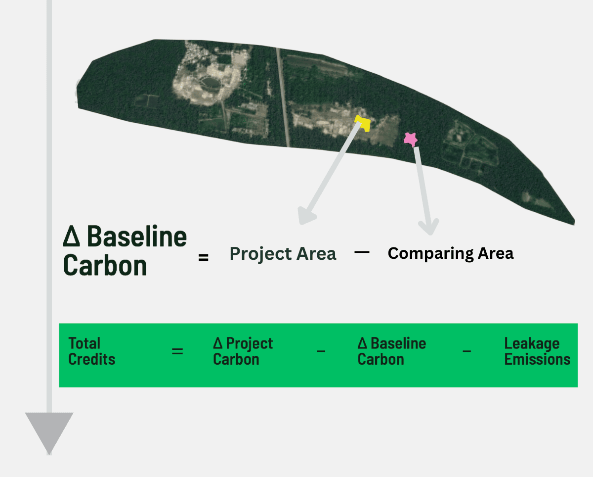
AGB alone doesn't prove additionality. Pair it with a dynamic baseline.
AGB Without Baseline = Phantom Credits
A forest that grew without your intervention still accumulates AGB. Without a dynamic counterfactual baseline, all that growth is incorrectly attributed to your project generating credits that don't represent real additional removal.
DCAB Uses AGB as Its Core Signal
Sylithe's Dynamic Control Area Baseline (DCAB) compares your project's AGB trajectory to statistically matched control areas. The additional AGB and only the additional AGB is converted to credits. This is the gold standard of additionality demonstration.
Annual AGB Updates Feed the Dynamic Baseline
Because AGB is remeasured annually from CHM, the DCAB baseline updates each year to reflect changing land use pressures, commodity cycles, and climate events ensuring your credits remain valid under evolving conditions.
Better data. Fewer deductions. More credits issued.
Wall-to-wall coverage at 10 m capturing forest edges, clearings, and heterogeneous regrowth that plot-based sampling misses.
Yearly remeasurement captures disturbance events, seasonal dynamics, and policy-driven land use changes in near real-time.
Allometric models calibrated across 40+ global forest types from Amazon terra firme to Miombo woodland and Southeast Asian dipterocarp forests.
Every AGB pixel is traceable to its CHM input, allometric model version, uncertainty coefficient, and verification date ready for third-party audit.
Carbon is a measurement problem before it is a market problem.
Sylithe is built on the conviction that every tonne of CO₂e issued as a credit should be traceable to a physical, measurable change in forest biomass verifiable by any independent party with access to the same satellite data.
By combining IPCC-grade allometry, space-borne LiDAR, and dynamic baselines into a single auditable pipeline, we give project developers, corporate buyers, and regulators a shared source of truth.
FAQs
How is Above-Ground Biomass (AGB) calculated using satellites?
Why is AGB calculation critical for carbon credits?
How does satellite AGB compare to manual field plots?
How does AGB convert into verified carbon credits?
Does Sylithe's AGB model work in tropical rainforests?
How often can AGB be updated for carbon reporting?
Issue credits backed by
measurement, not models.
Get a full AGB assessment for your reforestation or avoided deforestation project uncertainty-quantified, standard-aligned, and audit-ready.