 New
NewAfforestation &
Reforestation
Carbon that accrues as the forest grows, measured from orbit.
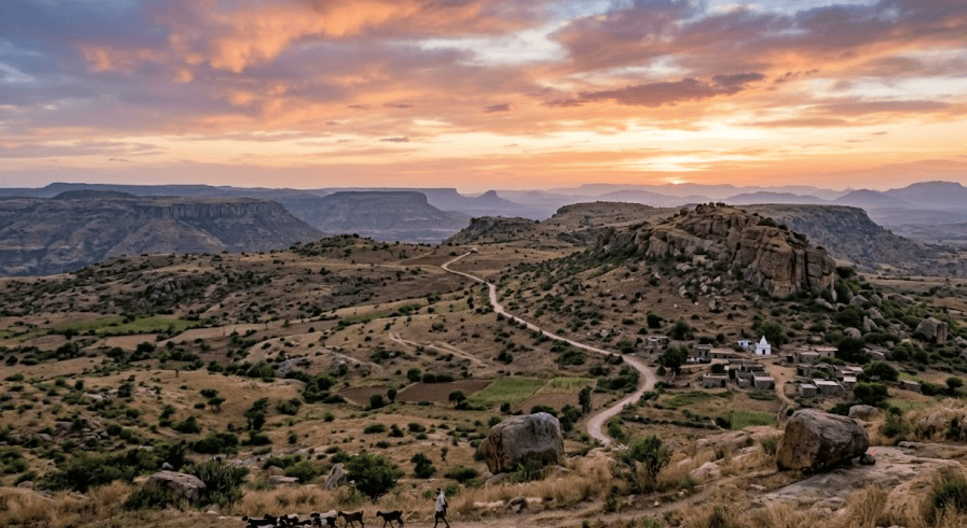
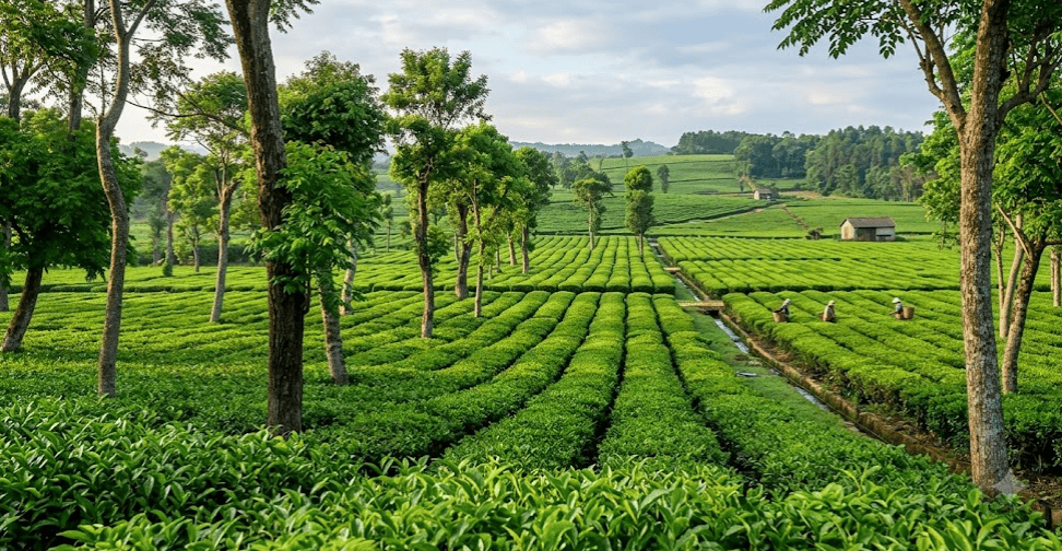
ARR is the most scaled removal pathway in the voluntary market and, for most buyers, the first one they ever bought. It is also the pathway where the market has learned the hardest lessons about baselines and over-crediting. The tonnes are real; what has to be rebuilt is the evidence around them, and that starts with measuring growth instead of modelling it.
3
activities: afforestation, reforestation, revegetation
20–40 yrs
typical crediting period
7.6 Gt
CO₂ forests absorb each year, globally
10 m
Sentinel-2 resolution behind eligibility screening
Market position
The most scaled removal category
ARR is the largest and usually the least expensive removal option on the voluntary market, and the one most corporate buyers already hold. That scale is also why scrutiny of ARR baselines and growth claims has sharpened faster than for any other pathway.
Removal profile
Gradual, and reversible
Carbon accrues year on year as biomass grows rather than arriving at a single moment. That makes ARR a long-duration asset with genuine reversal exposure to fire, drought, harvest and encroachment, which is exactly what monitoring has to stay ahead of.
Land
Degraded land, not standing forest
Eligibility turns on what the land was before the project began. Standards require evidence that the area was not forest at the start date, which makes historical land cover the first thing a verifier asks for and the first thing Sylithe establishes.
What has to be evidenced
Four checkpoints turn growth into a creditable tonne
At the land
Establish that the project area was genuinely non-forest at the start date. Historical satellite land cover, not a site visit, is what settles eligibility for a verifier.
At the baseline
Show what the land would have done without the project. A dynamic control-area baseline moves with real regional conditions instead of freezing an assumption made on day one.
At the canopy
Track structure as it changes. Canopy height across the whole area, resurveyed on a fixed cadence, is the physical record that growth actually happened.
At the carbon
Convert structure into biomass and biomass into CO₂e through documented allometry, with the uncertainty of each step carried through rather than discarded.
Why the growth has to be measured.
An ARR credit is a claim about a difference: what the carbon stock became, against what it would otherwise have been. Both halves of that subtraction are estimates, and the credibility of the tonne rests entirely on how each one was produced.
The mechanism
What a growing forest actually stores
Trees build their mass out of the atmosphere. Photosynthesis fixes CO₂ into cellulose and lignin, and the resulting structure holds carbon for as long as the tree stands. Roughly half the dry weight of woody biomass is carbon, which is why measuring structure is a legitimate proxy for measuring the removal.
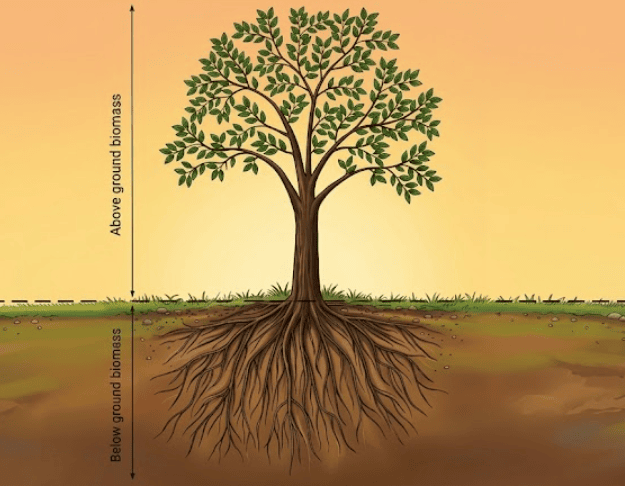
The stock sits in several pools. Above-ground biomass is the trunk, branches and foliage. Below-ground biomass is the root system, conventionally estimated as a ratio of the above-ground figure. Deadwood, litter and soil organic carbon accumulate more slowly and are treated conservatively or excluded entirely by most methodologies. What a project can credit is the measured change in the pools its methodology actually admits.
This is why ARR behaves so differently from an engineered removal. Nothing is fixed at a single moment. The asset accrues across decades, and every year of that accrual has to be evidenced rather than assumed from a planting record.
Quality
What decides whether ARR credits hold up
Two projects can plant the same number of stems on the same area and produce tonnes of very different quality. The variables that separate them are known, and every one of them is auditable.
- Survival, not planting: the number of seedlings put in the ground is a spend record, not a carbon record. What matters is how many are still alive and growing at each monitoring period, which only area-wide remote sensing can economically confirm.
- Species and structure: native mixed-species planting builds slower but more resilient stock and far stronger biodiversity outcomes. Fast-growing monocultures accrue quickly and attract proportionally more scrutiny from raters and buyers.
- Baseline realism: the counterfactual has to reflect what comparable land actually did over the same period, including the drought years. A benchmark that cannot move cannot be right for long.
- Monitoring cadence: a stock estimate is only as current as its last observation. Annual or better resurvey turns the crediting record into a time series rather than a pair of endpoints with a line drawn between them.
Sylithe records all four against every monitoring period, because which one a given rater treats as decisive changes faster than a crediting period lasts.
Evidence
Three independent lines of evidence
A defensible ARR claim does not rest on one dataset. Three separate strands converge, each closing a different gap an auditor would otherwise push on.
- The land was not forest: multi-year land cover classification from the satellite archive establishes the pre-project condition from an independent record that predates the project and cannot be reconstructed after the fact.
- The canopy actually changed: canopy height modelling across the full project area, resurveyed on a fixed cadence, shows structural change as a measurement rather than a growth curve fitted from planting records.
- The change converts defensibly: published allometric relationships appropriate to species and region turn structure into biomass, with propagated uncertainty stated openly so a verifier can qualify against the number rather than argue about it.
Scale
One pathway, two very different builds
ARR runs from a few hundred farmers with a hectare each to a single contiguous block of restored landscape. The ecology and the economics both differ, and so does where the MRV difficulty sits.
Smallholder and community planting
Thousands of small, non-contiguous parcels held by individual farmers or a community institution. Ecologically diverse and socially strong, but the parcel geometry is what makes conventional field-based MRV financially impossible at scale.
- High co-benefit density
- Fragmented parcel boundaries
- Per-plot ownership evidence
- Sub-hectare mapping required
Block plantation and landscape restoration
A single large area under one management regime, often on degraded revenue land or a corporate estate. Simpler to measure and to audit, but the additionality and species-mix arguments carry more weight because the counterfactual is harder to dismiss.
- Single management regime
- Simpler boundary evidence
- Higher monoculture scrutiny
- Larger leakage catchment
The cost problem inverts between them. A block plantation is cheap to survey and expensive to argue for; a smallholder mosaic is easy to justify and, under plot-based MRV, ruinously expensive to measure. Satellite-first monitoring is what makes the second archetype financially viable at all.
Permanence
A standing asset can be lost
Every tonne an ARR project claims stays claimable only while the biomass holding it stays standing. Fire, drought, pest outbreak, illegal harvest and conversion back to agriculture are all live risks across a forty-year crediting period, and standards price them rather than ignore them.
Managed: buffer and monitoring
A share of every issuance is withheld into a pooled buffer that is drawn down if a reversal occurs. The mechanism only functions when reversals are actually detected, which makes continuous monitoring part of the insurance rather than a reporting chore.
Unmanaged: the silent reversal
The damaging case is not a fire that makes the news. It is gradual degradation inside the boundary that nobody reports, credited for years before the next site visit finds it. That gap is a monitoring failure, not a forest failure.
This is why the monitoring cadence, not the risk score, is the number worth interrogating. A project that resurveys its whole area every season can evidence a reversal in the period it happened. A project that visits plots every five years cannot.
ARR credibility is a measurement problem.
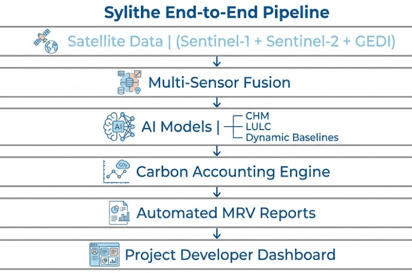
Unlike a biochar batch, an ARR project can be measured from orbit, and that is precisely the standard it should be held to. Sylithe replaces the sampled plot and the fitted growth curve with an area-wide, repeatable record of what the land actually did.
Eligibility and land history
Multi-year LULC classification reconstructs what the project area actually was before the start date, so the non-forest condition is demonstrated from the archive rather than asserted.
Baseline that moves
A dynamic control area tracks comparable land outside the project boundary, so the counterfactual reflects the drought, the policy change and the market shift that the project also lived through.
Canopy and biomass over time
Canopy height modelling and above-ground biomass estimation turn each monitoring period into a measured stock change, with the uncertainty stated instead of buried.
Standards & methodologies
One evidence set, multiple crediting routes
Sylithe structures ARR project data so the same underlying records can serve whichever pathway your buyers require.
 VCS
VCSVerra VM0047
The consolidated ARR methodology, built around dynamic performance benchmarks and remote-sensing evidence rather than the static baselines its predecessors allowed.
 GOLD STANDARD
Afforestation / Reforestation
A route that weights community outcomes and SDG contribution alongside tonnes, widely used by buyers procuring for co-benefits as much as for carbon.
 IC-VCM
Core Carbon Principles
Not a registry but the integrity bar above them. CCP labelling has become the practical filter corporate buyers apply before a nature-based credit enters a portfolio.
-nbGJm8Y8.png) BEE
BEEIndian Carbon Market / CCTS
India has both the degraded land base and the policy architecture for ARR at scale. Sylithe structures project evidence so it can travel into the domestic framework as it matures.
Developing an ARR project?
Whether it is a thousand smallholder parcels or a single restored landscape, the evidence requirements are the same. Let's establish the baseline and the land history before the first monitoring period, not after the auditor asks.
FAQs
Common questions from developers and buyers evaluating ARR carbon projects.