Protecting a forest does not make deforestation pressure disappear. It makes it move.
This is the central problem of carbon leakage in REDD+ projects. A project draws a boundary, secures funding, and claims credit for the trees inside. But the loggers, farmers, and commercial operators who were clearing that land do not stop. They relocate. They find the next accessible forest, the next unguarded hillside, the next community without a carbon contract.
If that relocated clearing is not tracked and deducted, the project is issuing credits for emission reductions that were never real at the landscape level. The trees inside the boundary are protected. The atmosphere is not.
This guide covers how leakage works, why the standard monitoring approach consistently underestimates it, and what landscape-scale satellite detection actually changes about the integrity of forest carbon projects.
Two Types of Leakage, One Outcome
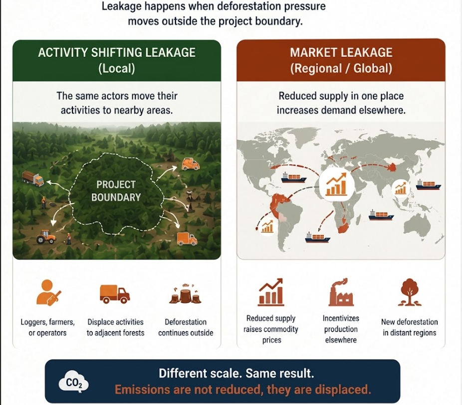
Carbon leakage splits into two categories that differ in scale and mechanism but share the same effect: net climate benefit smaller than claimed.
Activity Shifting Leakage
Activity shifting is local. The same actors move. A community that cleared forest for subsistence farming inside a project area, but was not given alternative income, will clear the nearest available forest outside the boundary. A logging operation displaced by a conservation contract relocates its equipment five kilometers down the road.
This type of leakage is theoretically detectable. It happens near the project, involves the same actors, and often produces the same spatial pattern of clearing. The tool designed to catch it is the leakage belt: a monitoring buffer around the project where clearing is tracked and deducted.
In practice, most leakage belts fail to catch even this.
Market Leakage
Market leakage is structural. When a large project removes a significant area from timber or agricultural production, it reduces regional supply. Prices rise. Higher prices make clearing land elsewhere more profitable. New clearing happens in regions that had no connection to the project, driven entirely by commodity market signals.
Most methodologies account for this using a fixed deduction factor: a standardized percentage applied to all projects regardless of commodity market conditions or regional clearing trends. That approach was a rough approximation when markets moved slowly. In a world of volatile commodity prices and fast-expanding agricultural frontiers, a static factor is not a measurement. It is a guess.
“Leakage is the shadow of a carbon project. To see it, you have to illuminate the entire landscape.”
— Sylithe Research
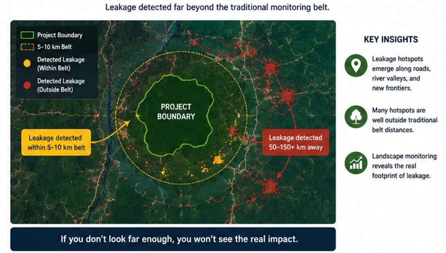
Why Leakage Belts Consistently Fail
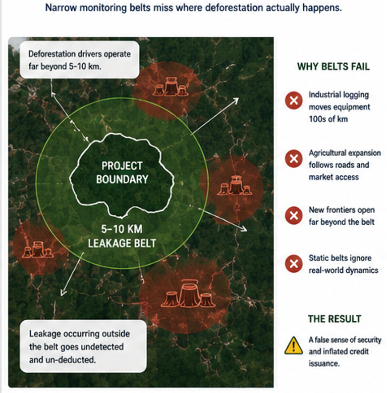
The standard leakage monitoring model assumes that clearing displaced by a project will stay close. Designate a 5 or 10 kilometer buffer, watch it, deduct what you find. Simple, defensible, and wrong in a growing proportion of cases.
Industrial logging operations move equipment over long distances. Commercial agricultural clearing follows road networks and market access routes that extend far beyond any narrow buffer. The assumption that displacement is local reflects how small-scale subsistence clearing works, not how most deforestation actually happens at scale.
A 2022 analysis of 26 large REDD+ projects found that deforestation increases in project-adjacent jurisdictions exceeded what narrow leakage belts detected by an average of 42%. The clearing was happening, just not where the methodology was looking.
The structural problem
Leakage belts are drawn by project developers. The width, location, and monitoring frequency are all chosen by the entity with the most to gain from low leakage numbers. The incentive is to draw the belt narrow and monitor infrequently.
What Landscape-Scale Detection Changes
What Landscape-Scale Detection Changes
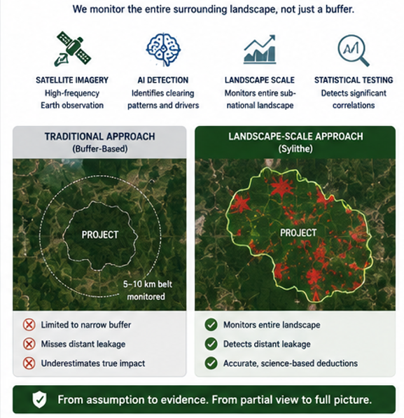
Catching leakage requires watching more than the project and its immediate edge. It requires monitoring the broader landscape continuously, with enough resolution to detect not just where clearing is happening, but what kind of clearing it is.
Different deforestation types leave different spatial signatures. Subsistence agricultural clearing produces irregular small patches along forest edges. Industrial logging leaves systematic linear patterns tied to road construction. Charcoal production creates dispersed small clearings in accessible forest. These fingerprints are distinguishable at scale in satellite data.
Sylithe's change detection models identify which clearing signature was dominant inside a project area before the project started. After project initiation, the same model scans the surrounding sub-national landscape for increases in that specific pattern. If subsistence clearing was the primary threat inside the project and subsistence clearing spikes in regions 30 kilometers away after the project begins, that correlation is a leakage signal, not a coincidence.
A Field Example: Central Kalimantan
In a project assessment conducted across a peat swamp forest in Central Kalimantan, Sylithe's landscape model identified that the project area had historically experienced clearing driven by small-scale drainage and agricultural conversion, a pattern tied to specific communities with road access along the project's western boundary.
After the project commenced in year one, clearing inside the boundary dropped by 91%. The narrow leakage belt registered minimal displacement. But the landscape model detected a 34% increase in the same drainage-and-conversion pattern in areas 15 to 40 kilometers to the north, where communities from the same region had expanded access through a new road opened in that period.
That leakage, invisible to the standard belt, accounted for approximately 18% of the project's claimed emission reductions in year one. It was deducted from credit issuance. Without landscape monitoring, those credits would have been issued.
Monitoring Is Not Enough on Its Own
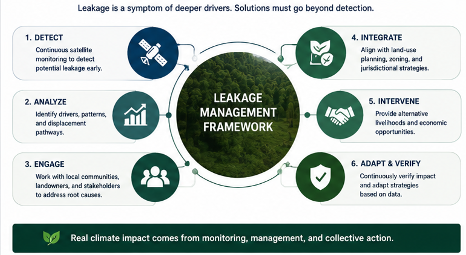
Better detection makes leakage visible. It does not make it stop.
Leakage is a symptom of unresolved pressure. Communities that depended on forest clearing for income and did not receive credible alternatives will find another forest. Logging operations under commercial contracts will follow the timber. The pressure exists independent of the project boundary.
The only durable solution is to address what created the pressure in the first place: alternative income for communities, sustainable agricultural intensification on already-cleared land, and land use planning at a jurisdictional level that makes high-pressure areas visible before they become leakage events.
Real-time leakage monitoring changes the management dynamic. When a project team can see a leakage signal emerging in a specific area 25 kilometers from the boundary, they can intervene before significant clearing occurs: dispatching community liaisons, adjusting benefit-sharing to include affected villages, or alerting jurisdictional authorities. Monitoring becomes a proactive tool rather than a retrospective accounting exercise.
What Buyers Should Ask About Leakage
Leakage accounting is one of the weakest areas of current carbon credit due diligence. Most buyers accept the leakage deduction listed in a project document without asking how it was calculated or whether it reflects actual landscape conditions.
- How was the leakage belt defined, and who defined it? Developer-chosen buffers have an inherent conflict of interest
- Does the project monitor beyond the belt? Leakage that happens outside the designated zone is still leakage
- How are market leakage deductions calculated, and are they updated annually to reflect commodity price conditions?
- Has the project detected any leakage signals since inception, and if so, how were they handled in credit issuance?
- Is leakage monitoring continuous or conducted only at verification intervals?
The buyer test
Ask your credit provider: 'Where did the deforestation pressure from this project go?' If the answer is that it disappeared, the leakage assessment is not credible. Pressure does not disappear. It relocates. The question is whether your verification system is wide enough to find it.
Carbon does not respect project boundaries. Monitoring that stops at the fence line is not monitoring the climate.
How Sylithe approaches leakage
Our platform replaces narrow developer-defined belts with continuous landscape-scale detection across entire jurisdictions. We identify leakage fingerprints specific to each project's threat profile, track them across the broader landscape, and apply real-time deductions to credit issuance. If you are developing or purchasing REDD+ credits and need leakage accounting you can defend under scrutiny, we should talk.
Key Takeaways & Metrics
A summary of the core concepts discussed in this article.
| Concept | Relevance | Impact Level | Status |
|---|---|---|---|
| Methodology | Core to accurate MRV | High | Active |
| Integrity | Essential for credit value | Critical | Mandatory |
| Technology | Enables scale | High | Growing |
Data synthesized from Sylithe Research.