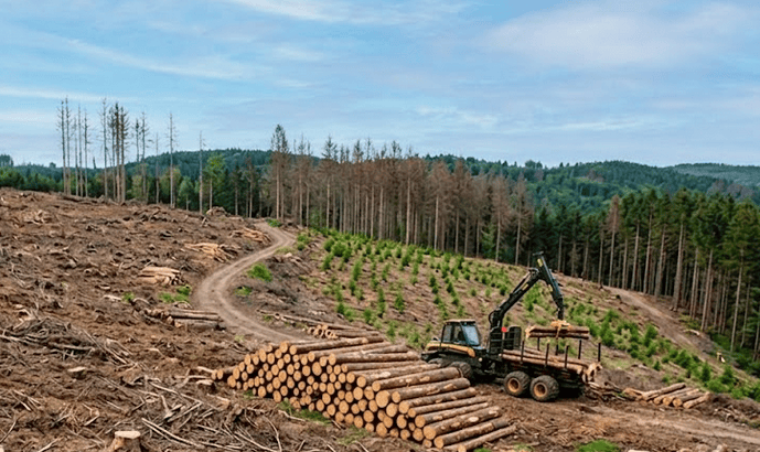
 New
New
The operationalization of the Indian Carbon Market (ICM) and the Carbon Credit Trading Scheme (CCTS) has fundamentally changed the rules of environmental asset creation in India. Managing a carbon asset by manually measuring tree trunks with clipboards and tape measures is no longer viable. The Bureau of Energy Efficiency (BEE) and global compliance buyers demand high-integrity, unalterable data.
For project developers across India—from agroforestry projects in Madhya Pradesh to large-scale ARR initiatives in the Western Ghats—the immediate challenge is navigating increasingly rigorous validation and verification frameworks. Deploying an enterprise digital MRV ecosystem like Sylithe from the very beginning enables satellite-grade carbon intelligence, automated monitoring, dynamic baselines, and audit-ready reporting that satisfies both Indian compliance authorities and international carbon registries.
The Indian Carbon Market is moving rapidly toward evidence-driven carbon accounting. Developers that continue relying on fragmented spreadsheets, periodic field visits, and manually generated reports face increasing operational risks, delayed verification timelines, and greater chances of project rejection. Modern carbon projects require continuous digital evidence rather than isolated field observations.
Navigating BEE and CCTS Validation Benchmarks
The Indian Carbon Market operates under a structured governance framework supervised by the National Steering Committee for Indian Carbon Market (NSCICM) and implemented through the Bureau of Energy Efficiency (BEE). Under the Carbon Credit Trading Scheme (CCTS), obligated sectors including steel, cement, aluminum, power generation, and other emission-intensive industries are expected to progressively improve greenhouse gas emission intensity. As compliance markets mature, project developers intending to generate carbon credits must satisfy significantly higher validation standards than those historically required in voluntary markets.
One of the largest reasons carbon projects fail during validation is the absence of transparent, auditable, and scientifically defensible evidence. Traditional monitoring approaches relied heavily on historical assumptions, periodic field surveys, manually prepared documentation, and static baseline projections. Modern compliance mechanisms increasingly require measurable demonstrations of additionality, permanence, transparency, and repeatability throughout the project lifecycle.
Independent Accredited Carbon Verification Agencies evaluate whether every reported carbon benefit can be traced back to verifiable observations. If a project cannot demonstrate how measurements were collected, how calculations were generated, and how monitoring continues after issuance, validation risks increase substantially. Developers therefore need monitoring systems capable of maintaining an uninterrupted digital audit trail.
Cloud-native satellite monitoring fundamentally changes this process. Continuous observation through optical satellites, radar imagery, vegetation analytics, biomass estimation, and automated reporting provides regulators with timestamped evidence instead of static documentation. Rather than collecting evidence only during verification cycles, developers continuously generate audit-ready datasets throughout the project lifetime.
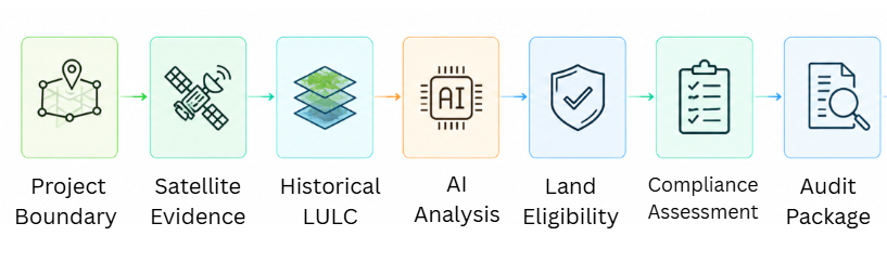
Manual field surveys, spreadsheets, delayed reporting, fragmented documentation, and high dependence on physical audits.
Continuous monitoring, automated evidence generation, cloud reporting, satellite intelligence, and audit-ready datasets available throughout the project lifecycle.
"Modern carbon compliance is no longer about proving what happened once every few years. It is about continuously demonstrating what is happening every day."
Solving the Land Eligibility Crisis in Indian ARR Projects
For Afforestation, Reforestation, and Revegetation (ARR) projects as well as agroforestry initiatives, land eligibility remains the first major regulatory hurdle. Before any carbon credit can be issued, developers must demonstrate that the project area satisfies historical land-use requirements established by both domestic compliance mechanisms and international registries such as Verra and Gold Standard.
Typically, project proponents must prove that the proposed land has remained degraded, non-forested, or otherwise eligible under applicable methodologies for an extended historical period. Traditional verification approaches often involve collecting decades of land ownership records, government documents, cadastral maps, historical photographs, and multiple rounds of third-party field investigations. These processes frequently consume several months while significantly increasing project development costs.
Satellite intelligence offers a substantially faster alternative. Instead of manually reconstructing land history from fragmented records, developers can analyze historical satellite archives spanning more than ten years. Long-term Land Use and Land Cover (LULC) classification, vegetation dynamics, and canopy evolution become immediately available through automated geospatial processing.
Using the Free Land Eligibility tools available through Sylithe, project developers can upload shapefiles or GeoJSON project boundaries directly into the platform. The underlying geospatial engine automatically processes historical satellite imagery, generates decade-long LULC timelines, evaluates vegetation transitions using Normalized Difference Vegetation Index (NDVI), and determines whether the proposed project area satisfies eligibility requirements before significant investments are committed.
Completing this screening during the earliest stages of project development dramatically reduces financial risk. Developers gain confidence that project boundaries comply with registry requirements before planting begins, improving investor confidence while minimizing expensive redesigns during formal validation.
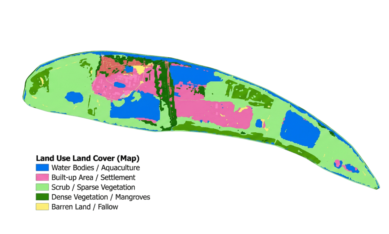
Delayed by months, dependent on fragmented records, expensive field verification, and greater rejection risk.
Instant 10-year satellite history, automated LULC analysis, NDVI trends, GeoJSON processing, and audit-ready evidence.
"Land eligibility should be validated before capital is deployed—not after millions have already been invested."
Shifting from Static Estimates to Dynamic Satellite Baselines
One of the most significant scientific weaknesses affecting carbon projects globally is the continued dependence on static carbon baselines. Conventional methodologies generally assume that carbon stocks within an unmanaged reference area remain relatively constant over long project durations. While this assumption simplified historical accounting methodologies, it no longer reflects environmental reality. India experiences highly dynamic climatic conditions characterized by irregular monsoon patterns, prolonged droughts, localized flooding, pest outbreaks, and continuous land-use changes. These variables directly influence vegetation growth, biomass accumulation, and natural carbon sequestration rates.
Static baseline methodologies often struggle to distinguish genuine project-driven carbon gains from environmental variability. For example, an unusually favorable monsoon season may naturally increase biomass across an entire region, while severe drought conditions could suppress growth even in well-managed restoration projects. Without accounting for these external influences, carbon accounting becomes increasingly uncertain and may either overestimate or underestimate the true climate impact generated by project interventions.
Dynamic baselines address this limitation by continuously monitoring carefully selected control areas that closely resemble the project site in terms of soil characteristics, climatic conditions, topography, vegetation type, and surrounding ecological conditions. Rather than relying exclusively on historical averages established years earlier, the baseline evolves alongside changing environmental conditions, creating a scientifically stronger comparison between project performance and expected natural outcomes.
Within the Sylithe Carbon Intelligence Ecosystem, dynamic baselines combine multi-temporal optical satellite imagery, Synthetic Aperture Radar (SAR), weather observations, terrain analytics, and GEDI spaceborne LiDAR measurements to continuously evaluate Above-Ground Biomass (AGB), canopy structure, vegetation density, and canopy height dynamics. The platform automatically updates comparable control areas, allowing developers to demonstrate that observed carbon gains result directly from restoration activities rather than external climatic fluctuations.
This scientific rigor substantially strengthens demonstrations of additionality and provides regulators with empirical evidence that project interventions create measurable climate benefits beyond natural ecosystem behavior. Dynamic baselines therefore improve both regulatory confidence and long-term carbon credit integrity.
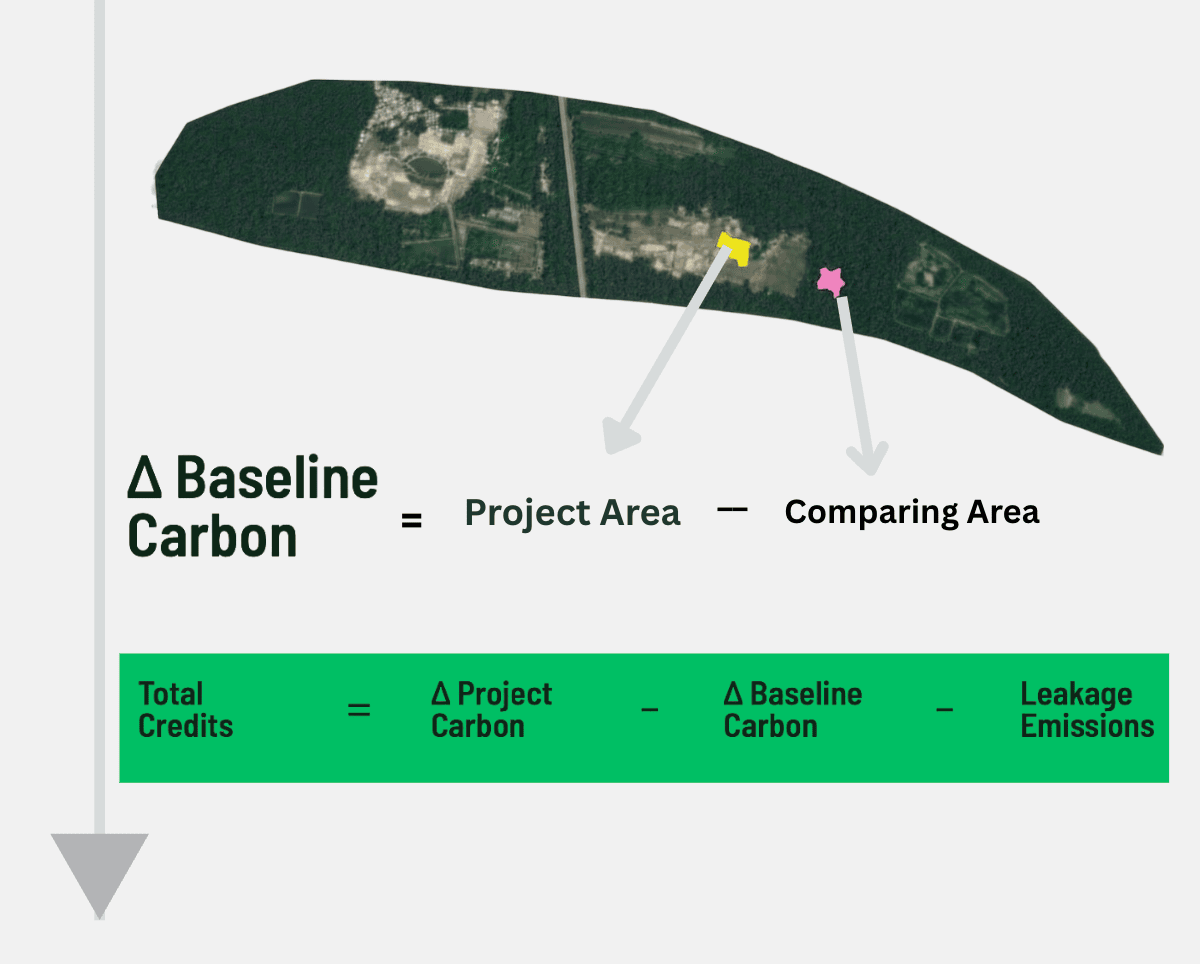
Fixed historical averages established once at project initiation with limited ability to reflect changing climate conditions.
Continuously updated control areas using satellite imagery, LiDAR, biomass estimation, weather intelligence, and machine learning.
"A baseline should evolve with nature. Climate is dynamic, and carbon accounting must become equally dynamic."
Mitigating Reversal Risks and Securing Premium Credit Pricing
Carbon permanence remains one of the most closely scrutinized indicators of carbon credit quality. Buyers, investors, registries, and regulators all seek confidence that carbon stored today will remain locked away for decades rather than being released through future disturbances. Reversal events—including forest fires, illegal logging, disease outbreaks, severe drought, storm damage, infrastructure expansion, or land-use conversion—can rapidly erase years of accumulated climate benefits while creating financial liabilities for both developers and buyers.
Within the emerging Indian Carbon Market framework, permanence is becoming increasingly important because compliance-grade credits must demonstrate long-term environmental integrity. Projects capable of continuously documenting forest condition, biomass stability, and ecosystem health are considerably better positioned to satisfy future regulatory expectations than projects relying solely on periodic manual inspections.
Continuous satellite monitoring fundamentally changes permanence management. Rather than waiting several years for scheduled verification visits, developers receive ongoing visibility into canopy condition across the entire project landscape. Machine learning algorithms analyze optical imagery, radar observations, vegetation indices, and biomass estimates to identify anomalies indicating canopy stress, deforestation, degradation, or biomass loss. These alerts enable rapid field intervention before localized disturbances evolve into large-scale reversal events.
Near real-time monitoring also increases buyer confidence. Institutional investors increasingly evaluate monitoring infrastructure alongside projected carbon volumes because transparency directly influences perceived project quality. Projects capable of continuously demonstrating environmental integrity often attract greater market confidence than projects providing evidence only during periodic verification cycles.
By integrating continuous monitoring, automated alerting, historical trend analysis, and transparent reporting into a single platform, developers create a comprehensive permanence management framework rather than treating permanence as a one-time verification exercise. This transition supports stronger credit quality while positioning projects for premium valuation within increasingly sophisticated carbon markets.
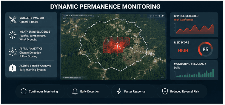
Long intervals between inspections increase the likelihood that degradation remains undetected until significant carbon losses have already occurred.
Automated monitoring delivers continuous environmental intelligence, rapid anomaly detection, and earlier intervention opportunities.
"The highest-quality carbon credits are not simply verified—they are continuously monitored throughout their entire lifecycle."
Accelerating Issuance Timelines while Reducing MRV Costs
Traditional Measurement, Reporting, and Verification (MRV) has historically represented one of the largest operational expenses for nature-based carbon projects. Developers often spend months organizing field campaigns, mobilizing survey teams, collecting biomass measurements, processing data manually, preparing compliance documentation, and coordinating independent verification. These fragmented workflows not only increase project costs but also significantly delay carbon credit issuance and revenue generation.
For many Indian project developers, delayed verification creates a serious financial challenge. Restoration activities require substantial upfront investment in land preparation, plantation activities, maintenance, community engagement, and ecosystem management long before carbon credits are issued. Extended MRV timelines therefore create prolonged cash-flow constraints that limit project scalability and discourage new investments.
Digital MRV fundamentally transforms this operational model by automating much of the evidence generation process. Instead of repeatedly dispatching field teams across thousands of hectares, satellite observations continuously collect environmental information while cloud-based processing pipelines automatically calculate vegetation indices, biomass estimates, canopy change, land-cover transitions, and other critical monitoring indicators. Developers receive continuously updated project intelligence without waiting months for manual compilation.
Automated reporting further simplifies compliance workflows. Rather than assembling verification reports from numerous spreadsheets, GIS files, field observations, photographs, and independent calculations, integrated reporting engines generate standardized compliance documentation supported by timestamped satellite evidence. These audit-ready reports substantially reduce administrative effort while improving data consistency across reporting periods.
Organizations implementing cloud-native digital MRV infrastructure can reduce recurring monitoring costs by approximately 40% to 60% while simultaneously accelerating validation and verification timelines. Lower operational expenditure, faster issuance cycles, improved transparency, and stronger scientific defensibility together create a significantly more scalable carbon project development model that benefits developers, investors, regulators, and carbon credit buyers alike.
Repeated field campaigns, fragmented reporting, lengthy verification cycles, higher operational expenditure, and slower credit issuance.
Continuous satellite monitoring, automated analytics, cloud reporting, lower operational costs, and significantly faster verification timelines.
"The future of carbon verification is not simply faster fieldwork—it is continuous digital intelligence."
Conclusion
The operationalization of the Indian Carbon Market represents more than the introduction of a new carbon trading framework—it signals a fundamental transformation in how environmental assets are measured, verified, and trusted. As compliance expectations continue evolving, developers who rely exclusively on manual monitoring and static reporting methodologies will increasingly struggle to satisfy both domestic regulators and international carbon registries.
Satellite intelligence, dynamic carbon baselines, automated reporting, historical land eligibility analysis, continuous permanence monitoring, and cloud-native digital MRV collectively establish a far more resilient approach to project development. These technologies not only improve scientific integrity but also reduce operational costs, accelerate verification timelines, strengthen investor confidence, and create higher-quality carbon credits capable of commanding premium market valuations.
For project developers building long-term restoration initiatives across India, digital monitoring should no longer be viewed as an optional technological enhancement. It is rapidly becoming the operational foundation upon which future compliance, transparency, scalability, and commercial success will depend. Organizations adopting these capabilities today position themselves to navigate India's evolving carbon market with greater confidence while contributing credible, high- integrity climate outcomes at national and global scales.
"High-integrity carbon markets are built on continuous evidence—not periodic assumptions."
Ready to Build an Audit-Ready Carbon Project?
Whether you are developing ARR projects, agroforestry initiatives, blue carbon ecosystems, or large-scale nature-based restoration programs, Sylithe provides satellite-grade digital MRV, automated land eligibility screening, dynamic carbon baselines, continuous monitoring, and investor-ready reporting to simplify compliance across India's evolving carbon market.
Indian Carbon Market Compliance Summary
A quick overview of the major compliance challenges and how satellite-grade digital MRV addresses them.
| Compliance Area | Traditional Approach | Digital MRV Approach | Business Impact |
|---|---|---|---|
| Land Eligibility | Historical documents & field verification | 10+ years satellite LULC & NDVI analysis | Faster approvals |
| Baseline Development | Static historical averages | Dynamic satellite control areas | Higher scientific integrity |
| Project Monitoring | Periodic inspections | Continuous satellite monitoring | Reduced reversal risk |
| Reporting | Manual documentation | Automated audit-ready reporting | Lower operational effort |
| Verification | Long audit cycles | Continuous evidence generation | Faster credit issuance |
| Credit Quality | Limited transparency | Continuous digital verification | Higher buyer confidence |
Framework synthesized by Sylithe Research based on emerging Indian Carbon Market compliance requirements.