 New
New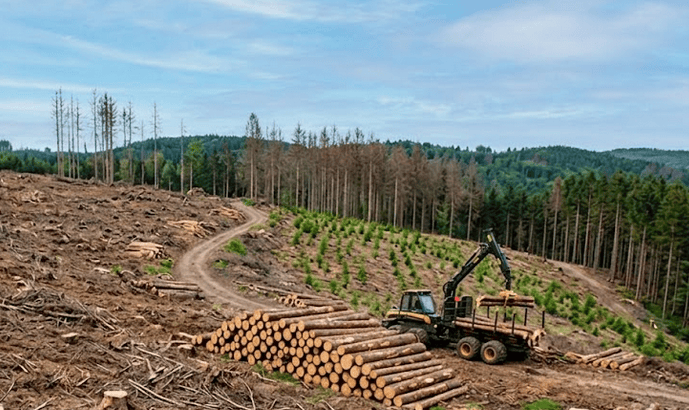
What Is AI Deforestation Detection?
A forest can be cleared in a week. Traditional audits find out in five years.
That gap between when deforestation happens and when the carbon market knows about it is where credit integrity collapses.
During those five years, credits backed by trees that no longer exist continue to be issued, traded, and retired. Buyers pay for climate impact that isn't there. Buffer pools go unadjusted. The market operates on a lie it doesn't know it's telling.
AI-powered deforestation detection closes that gap to 48 hours. This article explains exactly how the satellite data sources, the machine learning architecture, and why detection speed is now a core requirement for carbon credit integrity.
Why Traditional Carbon Audits Miss Forest Loss
Traditional carbon audits are built around human field teams: fly to a remote location, set up sample plots, measure tree diameters, compile a report. The process is expensive a single verification event costs $30,000–$100,000 and slow. Most projects verify once every five to ten years.
This creates a structural blind spot. Deforestation doesn't wait for audit schedules. Illegal logging operations move fast a new road pushed through overnight, a patch of primary forest cleared for agriculture in a week. If the last audit was in year one and the next isn't until year six, the project operates in a data vacuum for 80% of its life.
The consequences are documented and severe. In 2021, a major REDD+ project in the Brazilian Amazon suffered significant canopy loss from illegal gold mining encroachment. Because the next verification cycle was not scheduled for three years, credits continued to be issued and traded against forest area that no longer existed. By the time the reversal was formally recognized, over 400,000 tCO₂e in credits had been issued without physical backing. The buffer pool deduction, when it finally came, triggered a confidence crisis that affected pricing across multiple project types in the voluntary market.
This is not a fringe case. It is the predictable outcome of a monitoring system designed for an era when satellite data was expensive and AI didn't exist. That era is over.
“The carbon market has been asking buyers to trust that forests are still standing. AI gives us the ability to show them continuously, independently, and without ambiguity.”
How AI Detects Deforestation in 48 Hours
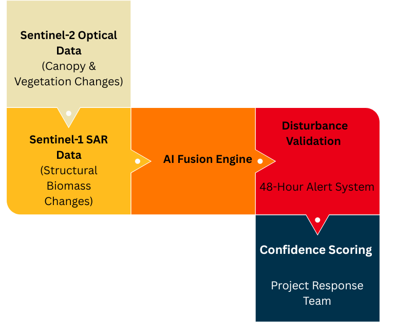
Sylithe's detection system is built on a Siamese Convolutional Neural Network architecture. Unlike standard image classifiers that analyze a single snapshot, a Siamese network processes two images of the same location simultaneously one from before a potential event, one from after and learns to identify the differences that indicate human-driven disturbance versus natural seasonal variation.
This distinction matters enormously in practice. A tropical forest losing canopy in dry season looks different to a satellite but it isn't deforested. Our models, trained on millions of labeled examples across diverse biomes, have learned to separate these signals with high reliability. A temporal attention layer extends this further: it analyzes the full historical sequence of each forest location to establish its natural variation range. Changes that fall outside this learned baseline trigger an anomaly flag.
Multi-Sensor Fusion: Sentinel-1 + Sentinel-2
Detection accuracy depends on using multiple independent data sources. Optical imagery from Sentinel-2 provides spectral evidence of canopy loss the shift in reflectance values as green canopy is replaced by bare soil or early regrowth. SAR radar from Sentinel-1 provides structural evidence the measurable drop in radar backscatter when the physical volume of vegetation is removed.
By requiring agreement between these two independent sensor types before flagging an alert, we dramatically reduce false positives. A cloud shadow that fools an optical sensor does not fool a radar. A radar glitch that looks like canopy loss is not confirmed by the optical signal. Only genuine, physical removal of forest biomass produces consistent signatures across both sensor types simultaneously.

False Positives vs False Negatives
A system that detects every disturbance but produces thousands of false alarms is unusable. If an alert pipeline cries wolf every time a cloud shadow passes or a tree loses its leaves during the dry season, field teams will quickly experience alert fatigue. Project developers simply cannot afford the logistical expense of deploying rangers to investigate natural canopy dynamics.
Conversely, a system that never produces false alarms but misses small-scale illegal logging is equally dangerous. If a model is tuned so conservatively that it only flags massive clear-cuts, the early warning advantage is completely lost. By the time an alert is generated, the reversal has already happened, and the carbon is gone.
Modern AI monitoring must carefully balance precision and recall. Precision asks: 'Out of all the disturbances the AI flagged, how many were real deforestation?' Recall asks: 'Out of all the actual deforestation that occurred, how much did the AI successfully catch?' In machine learning terms, this is the classic F1-score optimization problem, but with real-world carbon market consequences.
To solve this, our architecture employs a dynamic confidence thresholding mechanism. During peak logging seasons or in high-risk border zones, the model automatically lowers its confidence threshold—increasing recall—to ensure no potential encroachment goes undetected. During the wet season, when natural canopy changes are highly volatile, the threshold increases to preserve precision and prevent false alarms. This temporal and spatial awareness allows the system to maintain a high degree of technical rigor while remaining highly practical for on-the-ground enforcement teams. This is why multi-sensor fusion isn't just a technical feature; it is the fundamental mechanism that allows an AI model to achieve both high precision and high recall simultaneously.
The 48-Hour Deforestation Alert Pipeline
When a disturbance is confirmed, Sylithe's system generates a structured alert containing the GPS coordinates of the affected area, the estimated extent in hectares, the confidence score of the detection, the sensor data supporting the flag, and a timestamp of first detection. This alert is pushed immediately to the project developer's platform and can be integrated into local enforcement workflows.
In a 2025 pilot project across an 8,400-hectare forest corridor in the Satpura landscape of Madhya Pradesh, our detection system identified three separate encroachment events within a single monsoon season all of which occurred during a period when optical satellite imagery was completely obscured by cloud cover. SAR data from Sentinel-1 detected structural canopy loss on day 6 of each event. Alerts were pushed to the project developer and local forest department within 48 hours. In two of the three cases, field teams reached the location within 72 hours and halted further clearing. Total area lost: 23 hectares. Estimated area that would have been lost without early detection based on the encroachment trajectory: over 200 hectares.
Speed comparison
Traditional monitoring: disturbance detected at next audit cycle potentially 5 years later, after complete loss. Sylithe detection: disturbance flagged within 48 hours of satellite overpass, field response possible within 72 hours, loss contained at early stage.
Why Real-Time Monitoring Improves Carbon Credit Integrity
From a carbon market perspective, speed of detection changes the fundamental economics of reversal risk. Under traditional monitoring, a reversal event that goes undetected for five years means five years of credits issued against carbon that is no longer stored. Buffer pools the insurance mechanism that's supposed to cover reversals are sized based on projected risk, not observed outcomes.
Real-time detection enables dynamic buffer pool management. When a reversal is detected within 48 hours, the affected carbon volume can be immediately flagged, buffer pool contributions adjusted, and buyers notified before significant exposure accumulates. This transforms buffer pools from a backward-looking accounting mechanism into a forward-looking risk management system.
For project developers
Early detection means early intervention stopping encroachment before it becomes a material reversal. Projects with Sylithe monitoring have demonstrably lower reversal rates, which translates directly into higher credit quality ratings and stronger buyer confidence.
For credit buyers
Continuous monitoring provides the ongoing assurance that periodic audits cannot. Instead of trusting that forests are still standing, buyers can verify it through an independent, tamper-proof, continuously updated data stream.
From Detection to Prediction: The Future of Forest Monitoring
Detection is reactive it tells you deforestation has started. Sylithe's next layer is predictive: identifying where deforestation is likely to happen before any trees are cut.
Our predictive models analyze infrastructure development patterns new road construction, settlement expansion, agricultural frontier movement and correlate them with historical deforestation trajectories. Areas where these risk indicators are converging are flagged as high-risk zones, allowing project developers to concentrate patrol resources and community engagement efforts before encroachment begins.
In forest conservation, the difference between detection and prediction is the difference between containing a fire and preventing it. We are building toward a system where carbon projects don't just know what happened they know what's about to happen.
In the fight against deforestation, the only thing more valuable than data is the speed of that data.
Real-time monitoring for your carbon project
Sylithe's AI detection pipeline is currently active across multiple forest carbon projects in India, providing 48-hour disturbance alerts, dynamic buffer pool reporting, and audit-ready change detection records. If you're a project developer or credit buyer looking for the highest standard of monitoring integrity, we should talk.
Key Takeaways & Metrics
| Concept | Relevance | Impact Level | Status |
|---|---|---|---|
| Methodology | Core to accurate MRV | High | Active |
| Integrity | Essential for credit value | Critical | Mandatory |
| Technology | Enables scale | High | Growing |