 New
Planting trees is easy to report. Proving that they survived and grew is much harder. That is the gap Sylithe fills for companies.
Sylithe helps companies in India measure and prove their green work. Using satellite images, drone surveys and field visits, Sylithe measures a company's greenbelt against its environmental clearance condition, calculates how much carbon its trees store, tracks biodiversity around each site, and monitors Green Credit Programme land. All of this is shown on one dashboard per site, with every number linked to the image and date it came from. Companies then use this data in their EC compliance reports, BRSR, TNFD and CSR reports.
1. What Does Sylithe Do for Companies?
Most large companies in India make green commitments. A cement plant agrees to keep a greenbelt around its boundary. A steel company funds a tree plantation through its CSR budget. A listed company reports on land and biodiversity in its annual sustainability report. Some companies now restore degraded forest land under the government's Green Credit Programme.
Each of these commitments needs proof. Regulators, auditors, investors and the public want to know whether the trees are actually there, whether they are growing, and how much good they are doing.
Sylithe is a monitoring platform that provides that proof. For every site a company owns or supports, Sylithe measures:
- Greenbelt compliance: how much of the site is actually green, compared with what the environmental clearance asks for.
- Trees and canopy: how many trees there are, how tall they are, and how much of the ground they cover.
- Carbon: how much carbon the trees and soil hold, and how much more they take in each year.
- Biodiversity and water: the health of vegetation, habitats and wetlands, and which protected areas are nearby.
- Change over time: what the site looked like when it was first set up, and what has changed since.
The results go onto a dashboard for each site. Your environment team, sustainability team, CSR team and auditors all see the same numbers, and each number can be traced back to where it came from.
2. Why Do Companies Need to Prove Their Green Work?
For a long time, green work was reported as activity. A company would say it planted 50,000 saplings, attach a few photographs, and move on. Nobody went back five years later to check how many of those saplings became trees.
That is changing, and there is good reason for it. In August 2026, the Comptroller and Auditor General of India (CAG) tabled a performance audit of the Green India Mission in Parliament. Using satellite analysis of 153 sampled plantation sites, it found no change in tree cover at 107 of them. In other words, about 7 in 10 sites showed nothing for the planting that was reported.
This is not only a government problem. The same thing happens with company greenbelts and CSR plantations. Saplings are planted, some die in the first summer, some are never watered, and the report still shows the original number.
Today, several rules reward results instead of activity:
- Environmental clearance conditions ask for a measured share of green cover and for dead plants to be replaced.
- BRSR asks listed companies to disclose their impact on land and biodiversity, and BRSR Core brings some of this under reasonable assurance.
- The Green Credit Programme only gives credits if the land reaches a set canopy density after five years.
- Investors and global frameworks like TNFD ask how a company depends on and affects nature at each site.
The common problem is that the evidence is scattered. Field surveys sit with one consultant, photos sit in someone's phone, and the numbers sit in different spreadsheets. Progress is checked once a year, just before the report is due, when it is too late to fix anything. Sylithe brings all of this into one place and keeps it updated between reports.
3. What Is the 33% Greenbelt Rule in Environmental Clearance?
When an industrial project in India gets an environmental clearance (EC), the clearance comes with conditions. One of the most common is the greenbelt condition. In most industrial ECs, the company has to develop a greenbelt over at least 33% of the project area.
The condition usually says more than just the percentage. It often asks for:
- Native tree species, often planted in three rows or tiers around the boundary.
- A minimum tree density, often around 2,500 trees per hectare.
- A minimum width for the green belt along the boundary.
- Regular monitoring of survival, and replacement of plants that die.
Companies report on these conditions in their six-monthly EC compliance reports. The exact wording differs from one clearance to another, so the first step is always to read your own EC and note what it actually asks for.
The hard part is measuring it. A greenbelt may be spread across a large site, with some patches doing well and others dying. Counting trees by hand across hundreds of hectares is slow and expensive. And a single number for the whole site can hide a zone that is failing.
4. How Sylithe Measures a Company's Greenbelt
Sylithe starts with the site boundary and the clearance conditions that apply to it. From there, it builds a picture of the site using three sources of data, each one checking the others.
Satellite images
Satellites have been photographing India for decades. Sylithe uses this archive to see what the site looked like in the year it was established, and how its land cover has changed since. Regular satellite images also show the health of vegetation every season, so a patch that starts to dry out can be spotted early. Sylithe's land use and land cover classification maps the site at 10 metre detail.
Drone surveys
Satellites are good for the big picture, but they cannot always see individual trees. A drone survey captures images at 2 to 3 centimetre detail, which is enough to count trees and measure the shape of their crowns. Where tree-level precision matters, LiDAR is added to measure tree height. Sylithe uses this to build a canopy height model of the greenbelt.
Field visits
Remote data still needs to be checked against the ground. Sylithe's field team measures trees on sample plots, recording their diameter, height and species, and takes soil samples. These measurements are used to calibrate the satellite and drone results, so the final numbers match reality.
With all three combined, Sylithe reports for each zone of the greenbelt:
- The share of the site that is green, and the gap to your condition.
- Tree count and tree density.
- Belt width and how many tiers are present.
- Areas where trees are dead or missing, and where gap-filling is needed.
Because the results are split by zone, your EHS team can see exactly where to replant or water, instead of finding out at audit time that the overall number has fallen short.
5. How Much Carbon Does a Greenbelt Store?
Trees take carbon dioxide from the air and store it in their trunks, branches, roots and the soil around them. Some environmental clearances now ask companies to report the carbon taken up by their greenbelt, and many companies want this figure for their sustainability reports.
The usual shortcut is to multiply the number of saplings planted by a standard figure per tree. That gives a number, but not one that holds up well, because it ignores which trees survived, how big they actually are, and what species they are.
Sylithe measures it properly, in four steps:
Tree count and height come from drone and high-resolution satellite imagery.
Measurements from sample plots on the ground are used to correct the remote estimates.
Tree data is turned into above-ground and below-ground biomass, then into carbon, using IPCC 2006 and 2019 methods. Soil organic carbon is added from soil samples.
Every estimate has a margin of error. Sylithe reports it openly, along with the change since the baseline and the removals per year and per hectare.
One thing to keep in mind: greenbelt carbon is a removal, not a reduction in your own emissions. In sustainability reports, it should be shown separately from Scope 1 and Scope 2 emissions, not subtracted from them. If you are working toward a net-zero target, our guide on how corporate net-zero claims get verified explains why this matters.
6. How Sylithe Helps with BRSR Reporting
The Business Responsibility and Sustainability Report (BRSR) is the ESG report that SEBI requires from the top listed companies in India. It is organised around nine principles. Principle 6 covers the environment, and that is where most of Sylithe's data fits.
Under Principle 6, companies are asked about things like:
- Whether any of their operations are in or near ecologically sensitive areas.
- Their impact on biodiversity and land use.
- Steps taken to protect or restore nature around their sites.
Sylithe provides site-level figures for each of these: land cover and its change over time, green cover and greenbelt carbon, habitat condition, wetlands, and the distance from each site to the nearest protected areas. Each figure is tagged to the disclosure it supports, so your team can lift it straight into the report.
With BRSR Core, more of this information is now subject to third-party assurance. That means the auditor will ask where a number came from. Because every Sylithe figure links back to its satellite image, date and method, the answer is always available. You can read more about the specific BRSR Core KPIs in our separate guide.
7. What Is TNFD and How Can Indian Companies Prepare for It?
TNFD stands for the Taskforce on Nature-related Financial Disclosures. It is a voluntary global framework, published in September 2023, that helps companies report how they depend on nature, how they affect it, and what risks and opportunities this creates for the business.
TNFD is not a legal requirement in India today. But many Indian companies with global investors, lenders or customers are starting to use it, and it is closely linked to the kind of information BRSR already asks for.
TNFD suggests an approach called LEAP: Locate, Evaluate, Assess and Prepare. The first step, Locate, means finding out where your sites are in relation to sensitive nature, such as forests, wetlands and protected areas. This is where most companies get stuck, because they do not have consistent location data for every site.
Sylithe supplies this site-level evidence for each plant: land-cover change, habitat condition, wetland extent across seasons, and protected areas within 10 kilometres. It gives your team a solid starting point for the LEAP process without commissioning a separate study for each site.
8. How Sylithe Helps with the Green Credit Programme
The Green Credit Programme is a scheme run by India's Ministry of Environment that rewards companies for restoring degraded land. A company funds the restoration of a land parcel allotted through a state forest department, and can earn Green Credits once the restoration succeeds.
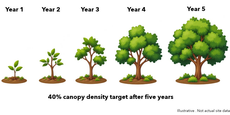
The key word is "succeeds". Under the current rules for tree plantation and restoration:
- Restoration has to run for five years.
- The land has to reach at least 40% canopy density at the end.
- Credits are based on surviving trees and canopy, not on the number of saplings planted.
- Credits cannot be traded, except between a holding company and its subsidiaries.
This means a company can spend money for five years and still not get credits if the canopy falls short. Sylithe helps reduce that risk at every stage:
Before you commit to a parcel, Sylithe checks its starting canopy, signs of encroachment and land condition from the satellite archive, so you know what you are taking on.
Canopy density is measured every year and compared with the 40% target, block by block, so you can see whether the parcel is on track.
Vegetation health is watched between assessments. A block that starts to fail shows up early, while there is still time to act.
Failing blocks are mapped down to the hectare, so the field team knows exactly where to replant, water or protect.
At the end of year five, the canopy map, survival record and full history are put together into one pack to support your submission.
Good to Know
Green Credits cannot be used to meet site-specific obligations such as the 33% greenbelt condition or mine-lease plantation. They can support compensatory afforestation, CSR and ESG reporting. Also, Sylithe does not issue Green Credits. Verification and issuance stay with the government's designated authorities.
9. Checking Carbon Credits Before You Buy Them
Some companies buy carbon credits to offset part of their emissions. The problem is that not all credits are equal. A forestry project may claim to protect or plant trees, but the satellite record can tell a different story.
Before you buy, Sylithe can look at a nature-based project from above and check basic questions: Are the trees actually there? Has the forest grown or shrunk since the project started? Is there any sign of fire, clearing or encroachment? These checks do not replace a full rating, but they catch obvious problems before money changes hands.
If you are new to this, our guides on how to buy carbon credits in India and what makes a high-integrity carbon credit are a good place to start.
10. How It Works, Step by Step
Working with Sylithe follows a simple path, from sharing your site boundary to seeing results on your dashboard.
- 1.Site onboardingYou share each site boundary (as a KML or GeoJSON file) and its clearance conditions. The site appears on your Sylithe dashboard the same day.
- 2.Satellite baselineSylithe rebuilds the site's land-cover and canopy history from the satellite archive, and adds high-resolution imagery for the baseline date.
- 3.Drone surveyA drone captures detailed imagery and canopy structure, with LiDAR where tree-level precision is needed.
- 4.Field sample plotsThe field team measures trees and takes soil samples to calibrate the models.
- 5.Analysis and quality checksTree count, biomass, carbon, greenbelt share and habitat indicators are calculated, reviewed and signed off, with their uncertainty.
- 6.Results on your dashboardResults, map layers and files appear on your site page. Your team reviews them, and monitoring continues between assessments.
What you get at the end is practical and ready to use:
What You Receive
| Output | Detail |
|---|---|
| Greenbelt share vs. your condition | By zone |
| Tree count, species and canopy | Per tree |
| Carbon stock and removals | With uncertainty |
| Biodiversity and wetland indicators | Per site |
| Drone and satellite map layers | GeoTIFF and KML |
| Methodology and uncertainty statement |
Behind all of this are a few simple principles. Satellite data is always checked against field data. Every number can be traced to its source image and date. Uncertainty is shown, not hidden. The same inputs always give the same results. And every version is kept, so you can show an auditor exactly what was reported and when.
11. Who Is This For?
Sylithe is built for any company that has greenbelt, plantation or restoration commitments. In practice, this usually means cement, steel, power, mining, oil and gas, chemicals and manufacturing companies, though the same approach works for any industry with land to look after.
Inside a company, different teams use the same data in different ways:
- EHS and compliance teams see their greenbelt status before the regulator asks, with a map of where to replant.
- Sustainability and ESG teams get defensible figures for BRSR and TNFD, including carbon and biodiversity.
- CSR teams can show what their plantation spend actually achieved, with survival rates and before-and-after images.
- Procurement and finance teams can check carbon offset projects before buying.
- Auditors and consultants get evidence they can trace back to the source.
Sylithe can also monitor sites that were planted years ago. Because the satellite archive goes back a long way, the full history of a site can be rebuilt from the year it was set up to today.
12. How to Get Started
Most companies start small. A typical first step is a pilot on one or a few sites: Sylithe sets up the baseline, measures the greenbelt against the clearance condition, and walks your team through the results. Once the approach works for you, it can be extended across all your sites, with regular updates in between.
All you need to begin is the site boundary and a copy of the conditions that apply to it. You can see more on the Sylithe for Corporates page, including a real before-and-after example of a site in Sanand, Gujarat.
Green commitments are made once, but proof is needed every year. Sylithe makes sure your company has it.
Talk to Sylithe
Want to see this on your own plant? Share your site with us and we will map your greenbelt against your clearance condition. Visit sylithe.com/corporates or write to info@sylithe.com.