 New
New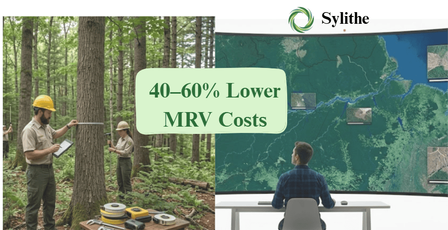
For a 10,000-hectare nature-based project, the difference between traditional MRV and Sylithe is not just a technological upgrade it is a ₹50,00,000 annual budget decision. We are decoupling environmental truth from physical logistics.
Key Takeaway
Nature-based solutions (NbS) including Afforestation, Reforestation, and Revegetation (ARR), Improved Forest Management (IFM), and REDD+ projects are the cornerstones of global carbon markets. However, their physical and geographic realities create a massive operational headache. High-integrity carbon credits require strict, empirical proof of carbon sequestration, additionality, and permanence. Gathering that proof has traditionally been a slow, expensive, and logistically punishing process.
Consider a typical mid-to-large-scale ARR project covering 10,000 hectares. Because carbon projects are rarely contiguous, this landscape is typically fragmented into 200 to 250 distinct plot areas or Areas of Interest (AOIs) spread across rugged, remote, and often inaccessible terrains. Under legacy methodologies, verifying that these 250 remote plots are actively growing, healthy, and undisturbed requires repeated, highly manual field audits and drone surveys.
The financial math of this traditional approach is brutal. When project developers are forced to run manual, physical audits every year, the economics of carbon credits collapse. Sylithe solves this problem by digitizing the entire MRV pipeline reorganizing it into a continuous, automated stream of evidence: Monitoring → Verification → Reporting. By replacing field teams and drone pilots with orbital AI, Sylithe reduces overall MRV costs by 40–60% while accelerating verification cycles from years to weeks.
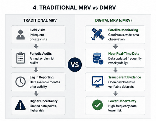
The Logistical & Financial Nightmare of Traditional MRV
To appreciate the scale of Sylithe's cost reduction, we must first look at the real-world operational costs that project developers face when using legacy MRV protocols. For a 10,000-hectare project distributed across 200–250 remote plots, traditional verification relies on two primary mechanics: manual forest inventory plots and drone-based photogrammetry.
Drone surveys are often presented as a modern solution, but at scale, they suffer from severe logistical limits. Drone mapping costs approximately ₹450 to ₹600 per hectare. This price includes hiring licensed drone pilots, transporting specialized RTK drone hardware to remote regions, and managing complex image processing.
For a 10,000-hectare project, the simple math is terrifying:
• Cost per hectare: ₹500 (average)
• Total project area: 10,000 hectares
• Cost for a single drone survey cycle: ₹50,00,000 (INR 50 Lakhs / $60,000 USD)
Spending ₹50 Lakhs every year just to capture raw imagery is a massive cash drain, yet the challenges run even deeper than the financial cost. The logistical realities of operating drones over 200–250 fragmented plots include:
Why It Matters
- Battery logistics: Commercial drones require multiple heavy batteries. Recharging 20–30 batteries a day in remote regions without grid electricity requires hauling diesel generators, adding to the carbon footprint and field costs.
- Terrain and access: Deploying teams to physical coordinates in dense forests, mountainous areas, or wetlands is hazardous. Travel time between 250 fragmented plots can consume weeks of field-team labor.
- Regulatory barriers: Drone flights require local airspace permissions, defense clearances, and weather-dependent scheduling. A sudden monsoon or windstorm can delay a survey by months.
- Temporal limits: Because of these costs and logistics, developers can only afford drone surveys once a year at most frequently leading to long periods where illegal logging, encroachment, or forest degradation go completely unnoticed.
₹50 Lakhs/Year Drone Cost
Linear cost scaling makes high-frequency drone surveys economically impossible. Developers are forced to compromise on data frequency, increasing project risk.
Remote Battery & Field Hazards
Hauling generators and scaling remote mountains to map 250 isolated plots creates massive operational delays and high safety overheads.
Regulatory Airspace Approvals
Acquiring no-fly-zone clearances and waiting for perfect weather windows makes continuous monitoring a logistical impossibility.
The 12-Month Blind Spot
Because drone and field audits only happen once a year, physical changes (like disease or logging) are often detected far too late, putting credit issuance at risk.
1. Monitoring: Replacing Repetitive Drones with Satellite Intelligence
Sylithe replaces expensive, slow, and repetitive drone flights with our advanced Satellite Intelligence Layer. Instead of flying drones over 250 distant plots, project developers access high-resolution satellite data directly through their centralized Sylithe Project Developer Dashboard.
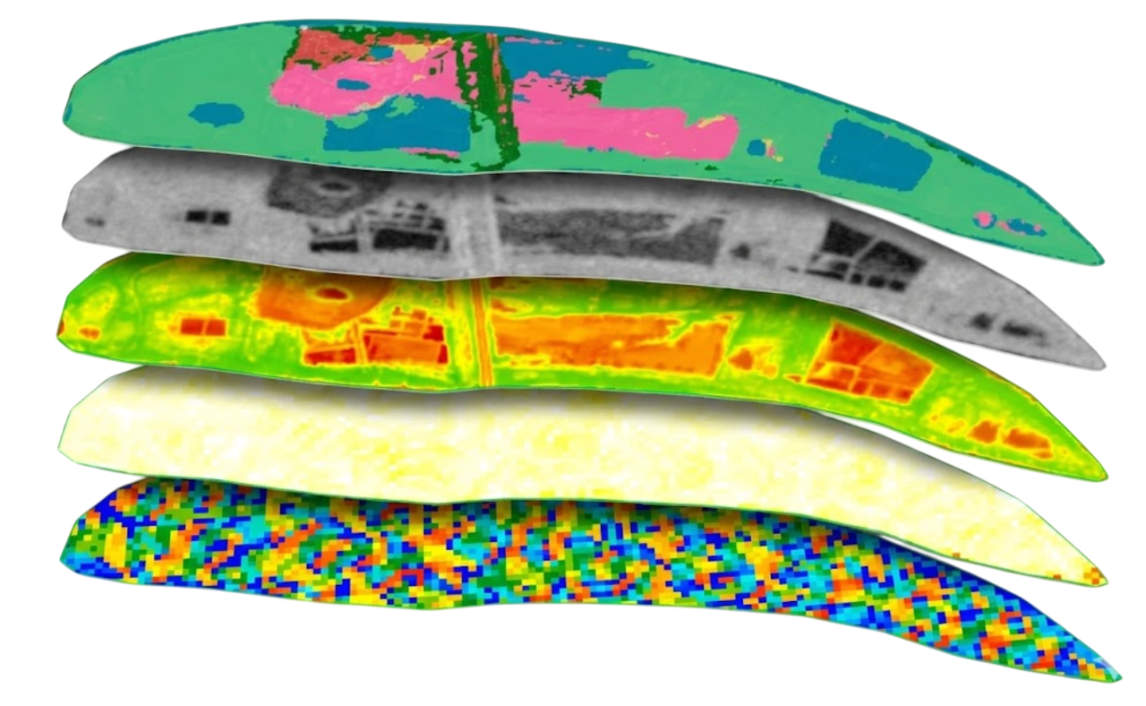
Sylithe builds a continuous digital record of the entire 10,000-hectare landscape by fusing multiple satellite constellations. We leverage sub-meter commercial optical imagery alongside open-access datasets from Sentinel-1 (Synthetic Aperture Radar) and Sentinel-2 (Multi-spectral). By combining these feeds, we achieve highly detailed observations of every single AOI without ever deploying a field team.
This orbital monitoring structure transforms the project economics:
High costs restrict monitoring to an annual basis. Physical deployment is plagued by logistics, bad weather, and airspace regulations. Total cost: ₹450-₹600/ha/year.
Continuous tracking available on a monthly, quarterly, or annual basis. Cloud-free radar fusion ensures uninterrupted data. Total cost: ₹150-₹220/ha/year a 60% reduction.
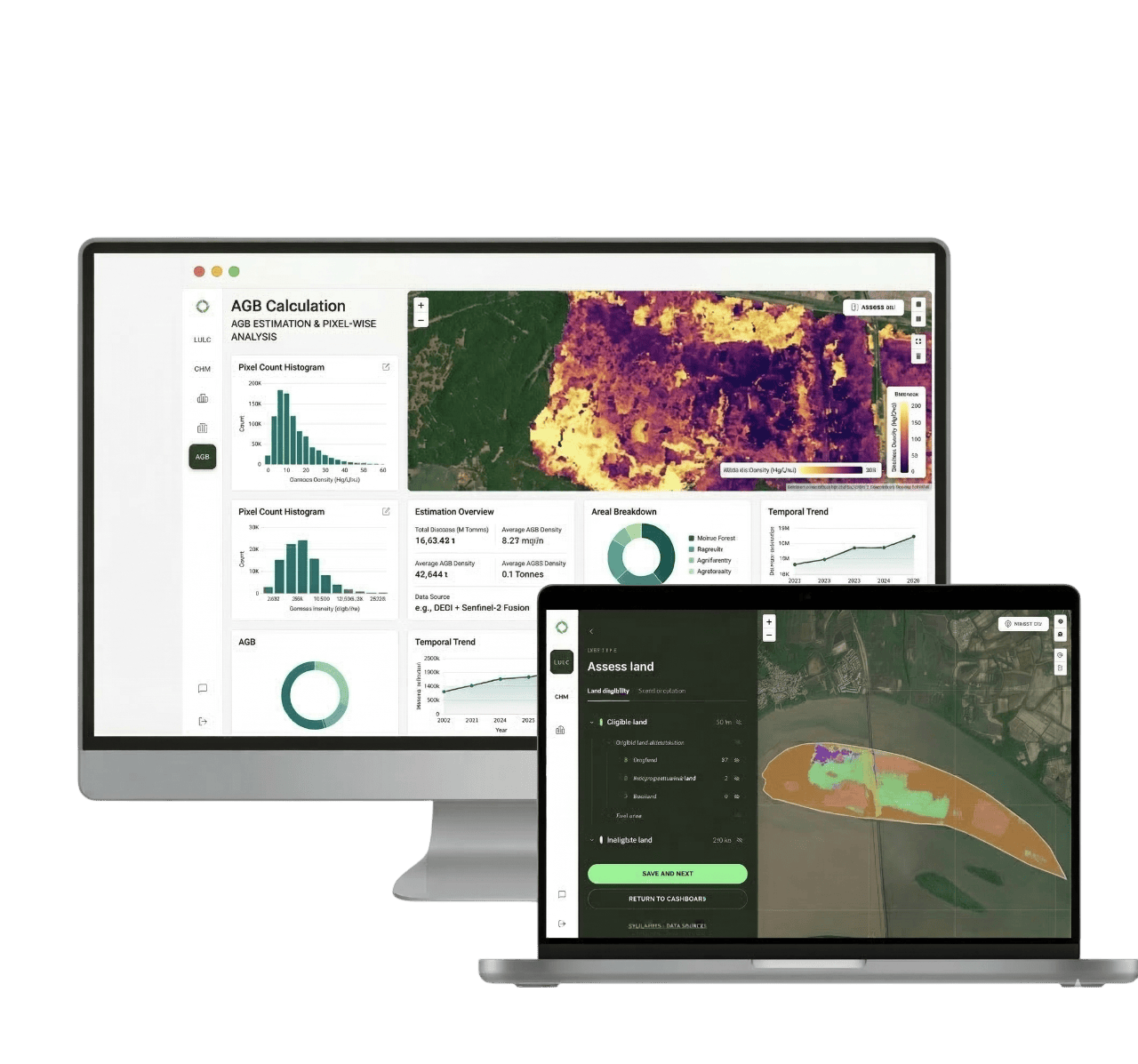
By using the Sylithe Dashboard, project developers can monitor all 200–250 plots from a single computer screen. If a developer needs to verify tree growth or check for unexpected forest disturbances, they do not need to send a field team or schedule a drone flight. They simply log in to their dashboard, select the specific plot, and view a time-series analysis of canopy greenness, moisture indices, and vegetation structure.
This continuous approach completely changes the timeline of project management. Instead of waiting 12 months for a drone report, developers can detect illegal logging or agricultural encroachment within days. This rapid response allows them to take immediate corrective action before significant carbon stocks are lost.
2. Verification: State-of-the-Art Geospatial AI models
Acquiring satellite imagery is only the first step. The true magic of Sylithe lies in our state-of-the-art verification engine, which translates raw satellite observations into verification-ready carbon metrics. Traditionally, verifying carbon sequestration required manual measurements of tree trunk diameter (DBH) and height, followed by static baseline calculations.
Sylithe automates this heavy analytical workflow using three proprietary, peer-reviewed geospatial AI models:
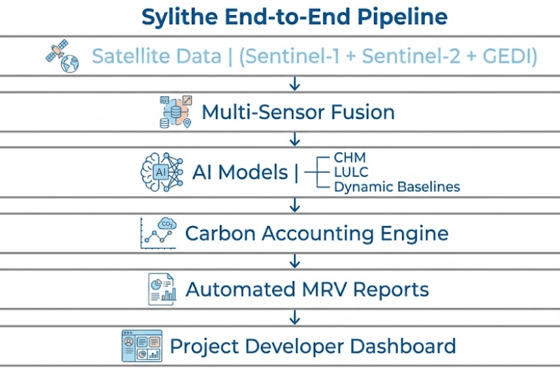
Our deep-learning models extract 3D canopy structure from multi-view satellite imagery and spaceborne LiDAR (GEDI). By calculating tree heights across all 250 plots down to a sub-meter level of precision, Sylithe estimates canopy volume changes over time without manual height sticks.
Using multi-temporal spectral fusion, our LULC classifiers achieve an accuracy of over 95%. The system automatically tracks land transitions (e.g., from degraded pasture to active forest) and maps species distribution across the 10,000 hectares, providing unquestionable proof of additionality.
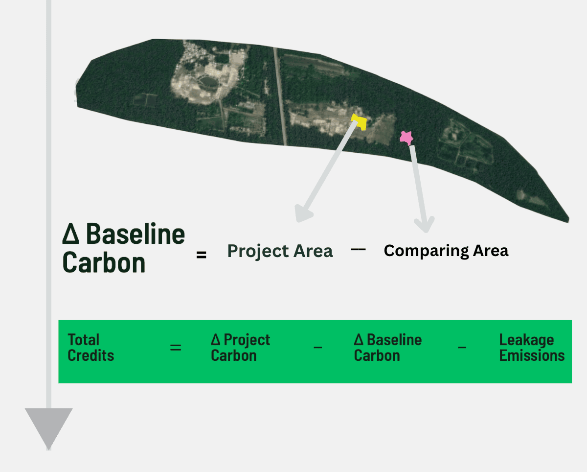
Rather than comparing your project to a static historical baseline that can quickly become outdated, Sylithe uses dynamic data. Our model matches your project plots with dozens of matching, un-restored reference regions (synthetic controls) to track carbon stock additions in real time, completely eliminating over-crediting risks.
By running these three models continuously, Sylithe creates an empirical, dynamic ledger of the forest's Above Ground Biomass (AGB). Instead of relying on manual field sample sheets (which are prone to transcription errors and sampling bias), developers can export verified AI-generated biomass maps that show carbon stock changes pixel-by-pixel across the entire landscape.
"Verification should not be a game of statistical guesswork. By replacing static historical projections with dynamic, real-time control regions and deep-learning canopy models, we provide buyers with empirical, mathematical certainty of every single **carbon credit**."
3. Reporting: Automating Verra & Gold Standard Compliance
The final step of the MRV workflow is the most painful: organizing years of monitoring data into massive compliance documents to undergo third-party auditing. Project developers routinely spend ₹15 Lakhs to ₹25 Lakhs per project cycle hiring carbon consultants to manually write these reports and align them with international standards.
Sylithe eliminates this manual bottleneck by automating the report generation process. The platform is built around the exact regulatory guidelines of the world's leading carbon registries:
Why It Matters
- Verra (VCS) Methodologies: Our data outputs, leakage calculations, and uncertainty quantifications are structured to automatically align with modern ARR methodologies (such as VM0047 and VM0048).
- Gold Standard Frameworks: Our dynamic accounting models generate clear proof of baseline permanence and community-level co-benefits, meeting the strict requirements of Gold Standard audits.
- Audit-Ready Documentation: The Sylithe Dashboard compiles all raw satellite observations, AI classification records, and calculation steps into an open, traceable, and timestamped digital record.
When it is time for an audit, the developer does not need to print thousands of pages of field notes or email massive zip folders of drone images to the VVB (Validation and Verification Body). Instead, they provide the auditor with secure, read-only access to their Sylithe Dashboard.
The auditor can click on any of the 250 plots, view the exact satellite imagery used, inspect the Canopy Height Model, review the LULC classifications, and download the dynamic baseline calculation scripts. This total transparency reduces auditor friction, cuts down on questions and clarification loops, and slashes the verification timeline from 12–18 months to just a few weeks.
Why Digital MRV Is Becoming The Industry Standard
Carbon markets are moving toward continuous monitoring, quantified uncertainty, and evidence-based verification. These requirements are difficult to satisfy through annual field campaigns alone.
Digital MRV combines satellite imagery, geospatial AI, cloud infrastructure, and automated reporting to create a scalable monitoring framework capable of supporting large landscapes and frequent reporting cycles.
As carbon registries continue strengthening integrity requirements, digital MRV is increasingly viewed as a foundational component of modern carbon project development.
The Bottom Line: Decoupling Cost from Scale
Traditional MRV vs Digital MRV
| Category | Traditional MRV | Digital MRV |
|---|---|---|
| Monitoring Frequency | Annual | Monthly / Continuous |
| Field Teams | Required | Minimal |
| Drone Operations | Extensive | Limited |
| Scalability | Linear Cost Growth | Improves With Scale |
| Audit Readiness | Manual | Automated |
| Data Availability | Periodic | Continuous |
The ultimate power of Sylithe's digital MRV infrastructure is that it changes the fundamental math of carbon project operations. Under traditional methods, your MRV costs scale linearly with your project's size and complexity. If you double your project area or add 100 new plots, your field-team and drone costs double as well.
Sylithe completely decouples cost from scale. Because satellite observations and AI classification run on cloud servers, the cost per hectare drops dramatically as your project grows.
This 40–60% cost reduction makes a massive difference in project viability. For a 10,000-hectare project, saving ₹40 Lakhs ($50,000 USD) every single year directly improves cash flow, allowing developers to invest more capital into planting trees, restoring local ecosystems, and supporting local communities.
Furthermore, it makes smaller-scale community and indigenous-led restoration projects (which were previously locked out of carbon markets due to high fixed audit costs) financially viable. By making high-integrity verification affordable at any scale, Sylithe is democratizing access to global climate finance.
Reduced Drone Overhead
Replacing yearly drone surveys across 250 plots with high-res satellite monitoring saves up to 50–60% on raw data collection costs.
Automated AI Verification
Proprietary CHM, LULC, and dynamic accounting models eliminate the need for expensive, manual statistical consulting.
Faster Auditing Cycles
Direct digital access for VVBs cuts validation and verification timelines from over a year to under a month.
Decoupled Cost Structure
Fixed cloud computing costs replace linear field-labor scaling, dramatically increasing margins as your carbon project expands.
Build Your Next-Gen Carbon Pipeline with Sylithe
As voluntary and compliance carbon markets mature, the standards of project integrity have never been higher. Buyers are no longer willing to pay premiums for credits backed by static spreadsheets and five-year-old field notes. They expect continuous, empirical, and transparent evidence.
Sylithe's digital MRV platform provides this evidence while reducing your operational costs by nearly half. By combining continuous satellite monitoring, state-of-the-art geospatial AI, and automated Verra/Gold Standard-aligned reporting, we help you build carbon pipelines that are highly profitable, completely audit-ready, and future-proof.
The future of nature-based carbon markets belongs to developers who can prove their impact cost-effectively. With Sylithe, integrity is no longer an expensive burden.
Ready to Cut Your MRV Costs in Half?
If you are managing a nature-based carbon project and want to transition away from expensive drone and manual operations, contact the Sylithe team today. Let's build a digital twin of your project and streamline your path to issuance.
Key Takeaways & Metrics
A summary of the core concepts discussed in this article.
| Concept | Relevance | Impact Level | Status |
|---|---|---|---|
| Methodology | Core to accurate MRV | High | Active |
| Integrity | Essential for credit value | Critical | Mandatory |
| Technology | Enables scale | High | Growing |
Data synthesized from Sylithe Research.